Sunday, April 24, 2011

Current Creek 042311

After a week of snow and temperatures near freezing, the south-facing slopes were ready for some serious powder harvesting.


I gathered the CMC crew at Woolly Mammoth HH at 7:30.  Cheryl, Phil, Vaune, Dave, Norm, Ginger, and Fred divided up the car pools and we drove off towards the slopes.  On the way out we saw Joel, but couldn't catch up to him until Downieville.  It was strange but encouraging to see fresh snow down low, and it only got better as we climbed.  The roads went from dry to wet to slush to snow-packed as we approached Berthoud Pass.  The snow was still coming down as we pulled into the trailhead parking lot.  


We delayed our start so Good Samaritan Fred could drive a skier with a dislocated shoulder to his car on top of the pass.  Soon we were all skinned up and ready to climb.  There was 4 - 8" of powder on top of the sun crust on the south-facing slopes, so we broke trail towards the Upper 110's saddle between Current and Second Creeks.  After a snack at the bottom of the slope, we ascended to the ridge and de-skinned.


As we headed down the crust made the descent pretty fast, but the ample powder on top made the turns come easier.  We had a quick bite at the bottom while half the group extended the down track a couple hundred feet, then we made another climb to the ridge.  A couple of other groups made use of the up-track, but graciously turned off to find their own powder.  

On the third run, some of us veered further west to take in some new terrain that ended up steepening at the bottom.  While we played on that slope, the faster members of the group found time for a fourth run at the ridge for a tree run on the west side of the ridge.

We regrouped at the lunch spot and began our traverse to the east.  A few of the group succumbed to the temptation of the untracked slopes, while the rest of us headed over towards the edges of Teacup Bowl.  We cruised down the gentle treed slopes to the bottom, despite a few encounters with unexpected dips in the flat light.  


3 - 4 runs, 3 miles / 1700 - 1900'
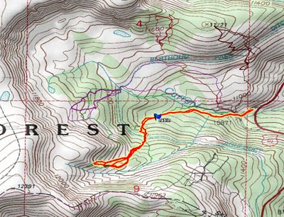
View the map and GPX on Every Trail. Zoom out to see the terrain map.
Upper 110s track with topo contours, slopes, and air photo.
Blue: 25-30°

Orange: 30-35°
Red: 35-40°
Dark red: 40-45°
Gray: 45-50°


Sunday, April 10, 2011

Mayflower Gulch 040911

Despite no new snow and 3 days of 40° plus highs, we managed to get a good workout on the snow at Mayflower.


Cathy had us meet at Woolly Mammoth at 7 and we were on our way to Summit County with Norm, Sandy, Phil, Judi, Kashia, Susan, Ginger, Fred, Bob, and John.  With no traffic to worry about and a refreshing stop at Frisco Safeway, we continued on to Mayflower.  It was all crust and ice at the TH, but patches of powder in the shade of the trees kept us optimistic.  The sun was toasty, if the 40 mph winds weren't raging.


At the Y before the cabins we headed right, up towards the well-developed cornice.  A few attempted to ascend to the ridge, but the blasts of unpredictable wind changed their minds.  Some of us headed through the trees on skier's left, where we found a mix of boilerplate crust and powder.  After surviving that run, we opted for a more open run through the glades, where powder spotting skills ensured survival.  The sun faded to gray as the storm clouds made a noon-time arrival.  New snow fell, but most seemed to whirl away in the wind.  Still, a third run beckoned us most of the way to the top, and we took a shot at the wide open slopes on skier's right.  Once again, the scalloped powder deposited by the wind was the best skiing.


We regrouped at the bottom at 1:30 and flew down the ice-glazed trail to the flats, where some of us limped the rest of the way to the cars.  


Half the group headed home, while the other half made a stop at ever-popular Tommyknockers.  


Back at Woolly Mammoth, the howling winds caught back up with us as we gathered up gear and headed home.


3 runs / 1600' / 5 mi

Sunday, April 3, 2011

Current Creek 040311

A crust day turns to powder thanks to heavy snow squalls at good old Current.

I gathered the crew at the Woolly Mammoth lot by the Conoco, and took off up the mountain with Cheryl, Kashia, Bob, Diane, and Renu.  After a stop at Downieville, we continued through Empire where it was raining.  Hope remained that the higher elevations of Berthoud Pass would turn the rain to snow, and we were not disappointed.  Before long we arrived at the TH where we were the only ones in the parking lot.  We skinned up and headed up the trail.  

Our hopes for powder in the trees were quickly shattered as the 40° plus temperatures during the week had baked everything to a lovely crust.  We passed the cabin on the way to the aqueduct, then followed the aqueduct to the climber's right to the glades.  The wind helped to drop some recycled powder, but the first run through the glades was breakable crust that was grabbing out downhill edges with less than desirable results.  After regrouping at the aqueduct, the sun faded and the clouds opened up to dump an inch or two per hour.  

Not bad for a day that started with wall-to-wall crust.
The second run in the bowl on climber's left was actually decent, and the smiles returned to the group.  At the meadow we dropped skier's left through the trees and back to the aqueduct to grab another installment of lunch.  


On the third climb up, it actually got colder as the air temperature dropped noticeably.  The third run was again though the left hand bowl, and this time it was really good.  Back at the aqueduct, we had enough powder to ski down the south-facing slopes for the first time in many a week.  Back at the trailhead we could not believe our good fortune.  Funny how fresh powder can really change the day. B-)


At the trailhead we bid farewell to a great powder day.


Sunday, January 23, 2011

Baldy Bowl 012211

Heavy deep powder provided some fun tree skiing at Baldy Bowl.


Lots of powder in the trees to enjoy.

On Saturday I joined the massive Callais CMC trip to Baldy Bowl with lots of others.  Forgive me if I leave off a name or five: Dave, Cathy, Sarah, Wendy, Judi, Ted, Will, Mark, Sue, Dan, Stuart, Susan, Norm, Phil, and Bob departed 4th and Union at 6:30.  Traffic crawled to Downieville, and after a stop, the caravan crept up through the snowfall to the tunnel, then to Frisco and on to Breckenridge where we met up with Candice.  Arriving at the Baldy Rd winter trailhead, we somehow managed to leave a spot or two unoccupied.  


We skinned up at the cars and skied over to the trailhead where a short powwow ensued.  Finally, around 10:30 we headed up the trail to the mine where we had a quick snack out of the wind, but mindful of the roof cornice hanging over the edge of the mine building.  


The horde settles in for a snack at the mine.
From there Dave led us uphill, then angling climber's left (north) to the trees.  The wind and heavy snow made it feel colder than expected, only for the skies to clear and have the sun out for a bit to warm up.  


The group split into two with Dave's group taking the open slopes on the edge of the trees and Dan's group climbing up through the foot-deep powder in the trees.  The snow was heavy but still passable, especially on the steeps and for those who hung back to take advantage of the slopes groomed by the first tracks bunch.


Lots of powder along the up-track.
At the bottom of the slope there was time for a couple bites to eat, then time to climb the well-packed uptrack.  The groups fragmented into smaller crews determined by timing and climbing speed, and then it was time for the second descent.  More goodness was enjoyed by those in the trees, though the open slope skiers were occasionally surprised by some wind-scoured hard pack.  Back at the mine it was already 2:00, much to our surprise.  Reluctantly, we headed back to the cars to pack it in and attempt to beat some of the traffic.  I drove a "secret shortcut" that by-passed the town of Breckenridge, coming onto route 9 at the 7-11.  We made it almost all the way to the tunnel traffic light, but had to wait through an entire 20-minute cycle before being allowed to continue.  The time passed relatively quickly watching telemark videos on YouTube.  Despite Loveland Pass being closed, there was the usual slowdown at the Loveland on-ramp, but speeds picked up from there, and we arrived at Tommyknockers around 4:00.  After a leisurely break, we hit the road back to town with traffic much reduced.


Stats: 4.4 miles / 1800' / 4 hrs


GPS track loaded at EveryTrail (click here).


Monday, January 17, 2011

Current Creek Chutes 011611

On our monthly Sunday trip, we found some decent powder in the Current Creek Chutes on the southwest side of the valley.


Dave swooshes through the powder.


I led a CMC trip to Current Creek on a Sunday with Cheryl, Kashia, Scott, and Dave.  We met at 7:00 at Woolly Mammoth, loaded up the cars, and hit the highway.  There was quite a bit of volume, but only minor slow downs on the way to Downieville.  From there, we avoided slow traffic by sneaking up the frontage road to the Empire turnoff, then on to the Current Creek trailhead.  We were on the snow before 9:00!  Several vehicles at the lot sported a couple inches of snow, leading us to expect some campers in the valley.  We headed up the drainage past the cabin, where a variety of boards for tele, AT, and snowboarding were stacked by the door.  


Past the cabin, we made the steepish climb to the aqueduct road, then continued our climb up to the Chutes.  A well-established up-track switched back and forth up the widest chute, then leveled off a bit when we hit the bottom of the yo-yo runs.  We continued climbing up a nicely powdered slope into an open bowl, then veered to the climber's left to ascend on the ridge through the trees.  We could only take so many tempting views of the untracked powder in the chute until we ripped the skins off and dropped into the powder.  We found light powder closer to the trees, with a mix of heavier powder in the middle with a few old tracks buried just beneath the surface.  


Scott glides down the lower chute.

Kashia swoops onto the lower slopes.

Cheryl joins the crowd at the skin-up spot.


After a pleasant run, we yo-yo'd the bowl a couple more times.  Except for a few crusty spots, the runs were very enjoyable.


Kashia cruises through the powder.


Kashia's chocolate covered coffee beans must have been having their effect on everyone, because we ended up back at the cars before 1:00.  We quickly departed to beat the Sunday traffic, only to find that there was none.  After a refreshing stop at Tommyknockers, we rolled back down to the park and ride.


3 runs / 3.0 miles / 1700'

The track for this trip is red with a yellow highlight
in the southwest corner of the bowl.  
The Peter Rabbit cabin is flagged with a waypoint.
The map and GPX track are also available on the EveryTrail web site.

Saturday, December 4, 2010

Berthoud Pass Meadows 120410

We enjoyed some nice powder at new terrain (to most of us) on the north side of the ridge on the west side of Berthoud Pass.


Sun and clouds at the top of the west side ridge at Berthoud Pass.


7:30 seemed plenty early when Cathy, Sue, Sandy, Cheryl, Mark, Norm, Dave, Ralph, and Tom met up at the 4th and Union park and ride.  As we headed up I-70, the stop-and-go traffic caused by a minor accident at Soda Creek had us thinking it was time for an even earlier meet time.


None of the Boulder crew joined us at Downieville, but after a refreshing stop we headed up to the Berthoud Pass parking lot.  The roads became snowier as we gained altitude, and the fickle weather alternated between sun and snow.  We chilled as we geared up with boots and skins, but quickly warmed with the climb to the ridge on the west side of the pass.  


As predicted by Dave's BP ski patrol memories, the top of the ridge was wind crust and scoured down to rock in places, but our hopes for better conditions were rewarded as we dropped into a well-tracked route on the north side of the ridge. A mix of crust and aeolian powder greeted us as we descended the track.  The lower we went, the better the powder became.  We regathered the group at an open space, then continued our descent below tree line where the snow gave way to silken untracked powder.  

After regathering at tree line, we descended 
through untracked powder in the trees.

We halted our descent at the brink of one of the steep chutes that connect the upper meadows with the aqueduct and the Current Creek parking lot. Despite the continuing tracks of many a boarder and skier, we opted to skin up and climb for another run.  

We skin up at the brink of the chutes.  
Low clouds/fog obscure our view.

After the rush of the downhill run, the grind of the climb was diminished.  Or maybe it was my new bindings with touring mode. B) 

Earning our turns with the climb for another run.
Clouds to the left and sun to the right 
on our climb for the second run.
Mines Peak shines through the clouds.

On our second descent, we opted for an untracked route through the trees, up over a hump, only to stop at the brink of another drop to the aqueduct.

The precipice beckons, but we hold our ground. US 40 
and the Current Creek parking lot are visible below.

Another skin up, and another climb.  The clouds part again for an expansive view of the Current Creek cirque and the Upper 110s runs.

Current Creek cirque and the Upper 110s 
form the backdrop for our third run.

Our third run was equally fun as we skied a relatively fresh run through the upper meadows and retraced our our first run through the trees to the previous skin up point.


Good turns on good powder in the meadow.

After the third run, it was time to plot our route back to the cars.  We climbed out of the trees to a high point, then veered skier's right to overlook a broad, steep-walled gully.  We traversed the gully, then split up to take our choice of routes below the cliffs or along an old run(?) paralleling the cliffs.  At the bottom, some skiers went to the road for a hike to the parking lot, some sidestepped up a track, and others contoured along the trace of the old road to end up at our starting point.  We packed up our gear with smiles on our faces, and adjourned to Tommyknockers for refreshment and sustenance.

Stats: 3.5 mi / 1600' / 6 hrs.
Slopes and topo map. Track in red with yellow highlight.
3D view in Google Earth looking southwest.
Parking lot is on the left.

A few more pictures are available on Picasa, and a map is on the EveryTrail web site.


Monday, November 29, 2010

Current Creek 112810

The day started with sunny bluebird skies when Sandy, Cheryl, and Tom left the 4th and Union parking lot at 7:30. Half an hour later, they met up with Diane at Downieville.


After a refreshing break, the crew headed up the hill to Berthoud and on to Current Creek. The parking lot had a few cars with people getting ready to hit the slopes. There was about 8 - 10 inches of powder on the approach, but some of the south facing slopes had a little bit of sun crust.


We followed the uptrack towards the Upper 110's, then kept to the track as it wandered aimlessly, finally coming to the glades at the head of the valley.   If only we knew who was responsible for the well-established track, we would commend them for their combination of skin track and snowshoe tracks leading to the usual starting spot.  However, any credit for this wonderful uptrack was totally negated by willful and careless damage inflicted on the beautiful powder slopes as they descended.  In any case, our crew opted for more vertical and untracked powder for their descent so we climbed a bit further to drop into the bowl to the left of the usual slopes.


Sandy, Diane, and Cheryl follow Tom's tracks to the meadow at the base of the middle bowl.
The snow was a bit variable with the combination of the previous days' wind loading and temperatures, but the untracked powder was too tempting to pass up.


We stop to admire our handiwork.

At the meadow halfway down the run, we dropped into the trees and had a great time winding our way back to the aqueduct.

Snack time prior to the next climb.

On the second run, Cheryl encouraged us to head over to the far bowl on climber's right.  There we met up with a motley group of telemarkers, AT skiers, and snowboarders.  One disgustingly young skier practically ran up to the top of the peak.  On his run down, the snow boomed and groaned distressingly.  All this noise convinced us to stay well away from the ridge.  After another snack, we headed down the slopes.

Diane, Cheryl, and Sandy cut over from the far bowl to the middle meadow.

By this time the clouds had moved in and a few light flurries were beginning to fall.

Cheryl and Sandy celebrate the run to the meadow.

After regrouping at the middle meadow, we headed through the trees again, this time ending with a thrilling slot through a final screen of trees and dropping into the aqueduct.  The unconsolidated deep fluff along the steep banks of the ditch provided ample excitement for the gang.

It's time to skin up and climb out of the aqueduct.

Back at the top, we decide to repeat our first run down the middle bowl.

Bundled up against the blowing flakes, Sandy, Cheryl, and Diane regroup in the middle meadow.

After three satisfying runs, we decided to head back to the trailhead via the ever popular Callais route.  The sun crust was minor, and the rocks were easily avoided.  After a quick shot through the luge run, we were at the bottom and ready to call it a day.  Despite the long weekend, ski traffic was minor, and Tommyknockers was nearly deserted.

Stats: 1850' / 3.5 miles / 6.5 hrs.

View the entire group of photos and movies here.